“I love it when a plan comes together.” -Hannibal, The A-Team.
What better way to spend a Saturday in the summer than eating a delicious meal in an airplane hangar, climbing to the top of the tallest all-granite building in the United States, and exploring the beaches and dunes of Cape Cod. After a wonderful trip to Provincetown, Massachusetts earlier in the spring, I planned to return this weekend to visit a historic landmark I did not have time to explore previously. When some friends asked me to join them for breakfast at a very cool restaurant at a small airport on the Cape, my plans were set. Add in a further adventure at National Seashore Park, and it all made for a wonderful day.
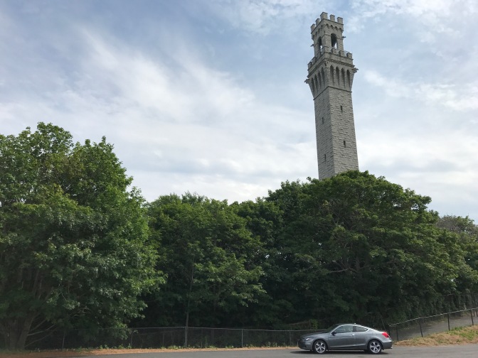
The primary motivation for my trip was to climb to the top of Pilgrim Monument, a 252-foot tall granite tower in the center of Provincetown. Before landing in Plymouth, the Pilgrims disembarked from the Mayflower on Cape Cod, near what would eventually become Provincetown. This was also the site of the historic Mayflower Compact, the document that the Pilgrims would use to govern their colony in Massachusetts. At the turn of the 20th century, it was decided to build a monument to commemorate the Pilgrims’ first landfall in the Americas. Constructed between 1907 and 1910, the structure is closely modeled after a tower in Sienna, Italy. Open to visitors, Pilgrim Monument is also the eighth-tallest monument in the United States (via Wikipedia).
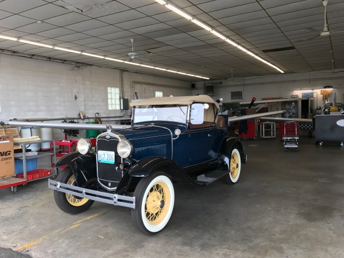
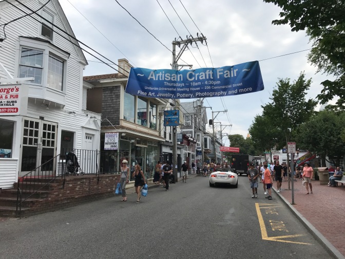
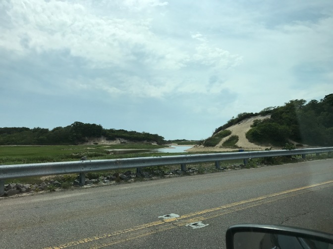
This blog’s third trip to Cape Cod. Our journey today takes us all the way to the northernmost tip: Provincetown. Our first stop, however, was in Chatman, in the southeast of the Cape.The first destination of the day was Chatham Municipal Airport. Housed in an airplane hangar, Stick and Rudder provides airplane servicing here (in the back are several planes being maintained). Of course, the 1931 Ford Model A car caught my eye.Besides maintaining aircraft, Stick and Rudder also provides aero tours of Cape Cod. This bi-plane was being readied to take a client into the skies.But our reason for coming to the airport was Hangar B, a very cool restaurant housed in another part of the same hangar as Stick and Rudder. The food was simply amazing. One of my friends ordered the Red Flannel Hash entree: hash made from beets, sweet potato, Yukon Gold potato, and bacon, served withe eggs, sourdough toast, and horseradish creme fraiche. Yum!The best reason to come to Hangar B is for the potato buttermilk donuts. They were amazing! Long a local secret, Hangar B now attracts foodies from around New England, especially after prominent reviews in the Boston Globe and Boston Magazine. It is a secret no more. We had to wait 45 minutes for a table (the wait was very, very worth it).Saying goodbye to my friends after breakfast, I continued northward and ran into a wicked traffic jam. I think the problem is all of these out-of-towners who come to Cape Cod from states such as New York, Pennsylvania, Connecticut, and New Jersey. Especially those New Jersey drivers! They clog up the roads!A half hour drive took almost an hour, but I arrived in Provincetown safely. Unlike my last trip in April when hardly anyone was around, P-town (as it is known) was bustling with people.Pilgrim Monument towers over every other building. As I walked to the tower, I passed this very quaint bed and breakfast.
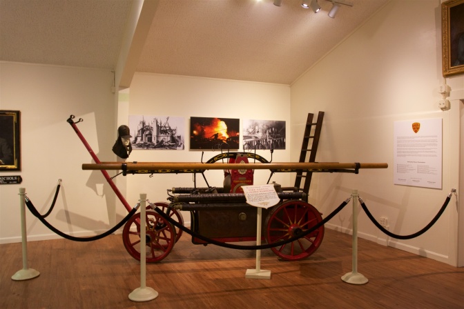
Arrived! You purchase your ticket to climb the monument in the Provincetown Museum. The museum provides an overview of the history and culture of Provincetown. Admission to the museum is included with your ticket.As I walked out of the museum and saw Pilgrim Monument, my fear of heights decided to show up. Right before climbing a 252-foot tall building. Of course.Pilgrim Monument was built atop High Pole Hill. The hill was so named because it was the location of numerous signals and flagpoles which were used to warn town residents and nearby ships of approaching storms.Ok, found my courage. Let’s do this! (A note about the seeming curved/angled appearance of the building. I use a wide-angle lens on my camera, and a wide angle lens will often distort straight lines of large objects like buildings, especially if you are looking up or down at the building when you photograph it. The only way to correct for this distortion is with what is known as a “tilt-shift” lens, which allows you to focus the lens on several axis, removing the distortions. Architectural photographers will use tilt-shift lenses in their work. A Canon tilt shift lens costs anywhere between $1800 and $2400. So, dear reader, unless you choose to mail me a tilt-shift lens, pictures like these may have some distortions.)As I began to climb the stairs, I came across these stone engravings which recognize various organizations that contributed to the construction of the monument. Many towns in Massachusetts and Rhode Island also contributed funds to the monument. Towns such as Cambridge, Watertown, Natick, Swansea, Boston, Bristol, Bridgewater, Somerville, Dorchester, Braintree, Falmouth, Raynham, Fall River, Hanover, and Dartmouth are recognized. After a few flights of stairs, I was pleasantly surprised to find that most of the climb would be not with steps, but with gently sloping ramps. There are 116 stairs (mostly at the very bottom and very top), but the majority of the climb is made using 60 ramps. It was a very easy walk!Windows provide light and ventilation as you proceed to the top.I made it! This image is looking west, toward Provincetown and the dunes beyond.The southward view, including Provincetown harbor.After descending from the monument, I stopped by the Provincetown Museum to check out the exhibits and cool off. This display about schooners caught my eye, especially after my journey aboard the Thomas E. Lannon earlier this month.This exhibit, on the wreck of the HMS Somerset, piqued my interest. The Somerset was a British warship that ran aground off Provincetown in 1778 during a storm. Paul Revere’s journey to warn Lexington and Concord took him past the Somerset on the night of April 18, 1775. Later, the Somerset participated in the Battle of Bunker Hill. Finally, Henry Wadsworth Longfellow included the Somerset in his poem The Ride of Paul Revere. This ship has been included in quite a bit of American history. This single exhibit also captures four different posts from this blog!When you have a four-century old fishing village, made almost entirely of wood, that was also home to whale oil production for much of its history, you have a recipe for fires. Provincetown has seen 17 significant fires in its history (the most recent in 1998). This hand-pumped fire engine, the George Washington, served Provincetown from 1839 – 1869.This scale model of the Mayflower was impressive, detailed, and very lifelike. I do not have dimensions for it, but I am 5’9″, and the model was taller than me.Overall, though, I was unhappy with the museum for one major reason. The museum’s mission is to tell the history of Provincetown and Cape Cod, yet there were Native Americans on Cape Cod for thousands of years, and there was hardly a mention about them here. In the foreground is a display case of Native American jewelry and other small objects. Aside from brief descriptions, there was no attempt to provide a larger narrative of the importance or meaning of these items. In the background is a mural depicting the first encounter between Pilgrims and Native American inhabitants of Cape Cod that resulted in a skirmish with rifle and arrow fire (no one was injured on either side, apparently). Thousands of years of history, and that was all the information provided. As someone who has Native American ancestry, I was disappointed.Obligatory DH-and-Pilgrim-Monument photo.
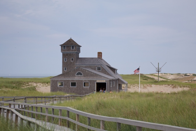
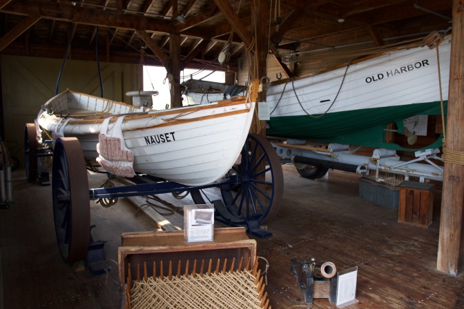
After the museum, I got in my car and headed north to Race Point Beach, to visit the Old Harbor Life-Saving Station. Originally built in Chatham in 1897, the station was moved to Provincetown when beach erosion threatened to send it tumbling down into the Atlantic Ocean. Originally staffed by the United States Life-Saving Service (a precursor to the US Coast Guard), the station was crewed by 7-8 rescuers (or “lifesavers”) who would be responsible to go into the ocean to save the lives of sailors whose vessels had wrecked off the shores of Cape Cod. Through rain, snow, ice, hail, hurricanes, frigid cold, and blistering heat, these “surfmen” (another name for the “lifesavers”) would be the saviors for thousands of sailors who needed rescue at sea.
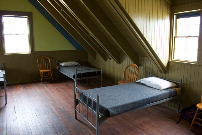
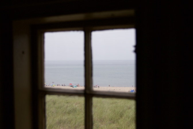
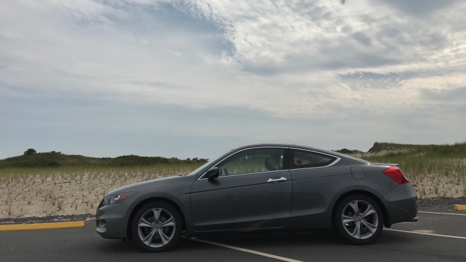
Even though I consider myself a decent photographer, I can not capture the majesty of the dunes of Cape Cod, despite my best efforts. This photo looks nothing like how this scene appears in real life. You will have to take my suggestion and visit for yourself!Built in 1897, the Old Harbor Life-Saving Station was in service until 1944. It was moved to its current location in 1977 and is overseen by the US National Park Service.The dining room of the station. Despite being 120 years old, the park rangers estimate that the building is 90% original. It has been furnished to appear as it would have looked around the turn of the 20th century.The staff’s quarters. I am pretty sure that if my bed was the one in the foreground, I would have hit my head on that A-frame every morning. Every single morning.According to the park ranger I spoke with, this yellow room was specifically used when women were housed in the station (such as if a woman was rescued from a ship).Through these very windows, the surfmen would have kept watch for signs of shipwrecks. Today, all that can be seen are people enjoying a relaxing day on the beach.This chest represents a typical portable library that would have been passed between stations. It was a spartan existence for the men stationed here, with little in the way of entertainment.Imagine it is two in the morning. A violent winter storm rages outside, snow and sleet pelt the window beside your bed, and the wind, at times gusting to 50 miles per hour, howls. Waves, some as high as thirty feet tall, crash against the shore. You have just managed to fall asleep when your commander wakes you and tells you to get dressed: a ship has just wrecked and you and your fellow lifesavers need to go rescue them. And these little 30-foot long boats will be how you head into the ocean, into the raging storm. That is the life of a surfman.Looking out at the dunes of Cape Cod and the sea, from a window high atop the station.One last picture of my car in front of the dunes before heading home. As I have mentioned before, DH doesn’t look like himself without sea spray on his paint and sand in his floor mats.
My third adventure this year through Cape Cod was memorable and thoroughly enjoyable. Hangar B Eatery is open every day during the summer season from 7:00 am – 2:00 pm. Pilgrim Monument is open year round. Tickets are $12 for adults, $10 for seniors 65 and older, and children ages 4 – 12 are $4. Finally, Old Harbor Life Saving Station is free, but access to the National Seashore Park beaches are $20 per car during the summer season (however, parking is free during the off-season).
For me, the Cape is a welcome respite, a sanctuary from the stresses and trials of life, where I can re-energize for the coming weeks ahead. I will continue to explore the national treasure that is Cape Cod, and will also continue to bring you stories of my travels there. I hope you enjoyed this post, and thanks for coming along on another journey down the open road ahead!
Haha, I just keep picturing you waking up in that twin bed under the A-frame and bonking your head. I’d pay good money to see that ;). What a great view of P-Town from the top of the tower! That’s one area I’ve always wanted to visit. Now, about those pesky NJ drivers. Always causing trouble.


Looks great! U are really discovering some interesting places!
LikeLiked by 1 person
Haha, I just keep picturing you waking up in that twin bed under the A-frame and bonking your head. I’d pay good money to see that ;). What a great view of P-Town from the top of the tower! That’s one area I’ve always wanted to visit. Now, about those pesky NJ drivers. Always causing trouble.
LikeLiked by 1 person
Indeed. “Good morning!” (bonk). You’ve got to get to Cape Cod at some point. So much to see and do!!
LikeLike
Awesome as usual 🙂
LikeLiked by 1 person
Thanks! Glad you enjoyed it!
LikeLike